
Posted by J & V on Mar 11th 2024
Palo Duro Canyon: Two Days of Hiking
This weekend we traveled to a state park in Texas that is known as the Grand Canyon of Texas and is the second largest canyon in the United States. It is Palo Duro Canyon State Park, located near Amarillo, Texas. We had only seen pictures of this park and videos from other travelers, giving us some Bryce Canyon (Utah) vibes with the orange landscape and tall rock formations (hoo-doos). This landscape is like none other in Texas and we had to check it out.
The canyon stretches 120 miles long, up to 20 miles wide, and is up to 800 feet deep The hiking trails cover 15,000 acres around the park and include traversing over cliff edges, climbing up peaks, down into the canyon, and into some caves. Palo Duro is part of the Caprock Escarpment located in the Texas panhandle, southeast from Amarillo and 14 miles East of the town of Canyon. The park is very easy to get to and the inside is very accessible with a two lane paved road that leads you through the park to campgrounds, day use areas, trading posts, shops, and trailheads. There are many pull-offs from the road that aren't marked on the map where you can park your car, snap some photos, and walk to a trailhead nearby. Besides hiking, you can mountain bike on many of the trails and horseback ride on certain designated paths. Just outside the park you will see companies that offer horseback riding tours through the canyon.
Our journey into Palo Duro begins after paying the entrance fee and we descend into the canyon, slowly driving down the winding switchbacks that will lead us to the visitor center on the right. There is a parking lot above the visitor center with a steep one-way drive leading down to the center and another small lot, which is not seen from the road above. But it is well worth going to the visitor center to see the history of the canyon, artifacts, fossils, artwork, and souvenirs. Some of what we learned about the park is that in 1934 Texas bought the 20,000 acres and the construction of the park road was between 1933 and 1937 done by the Civilian Conservation Corps (CCC). They also built the headquarters, bridges, cabins, Coronado Lodge Interpretive Center, and picnic areas. Outside of the visitor center is a great photo opportunity with a vast overlook for that side of the canyon. To leave that parking lot, drive past the center and up another steep once way drive that leads back to Park Road 5. We turn right onto the road and continue on our winding way into the park.

DAY 1
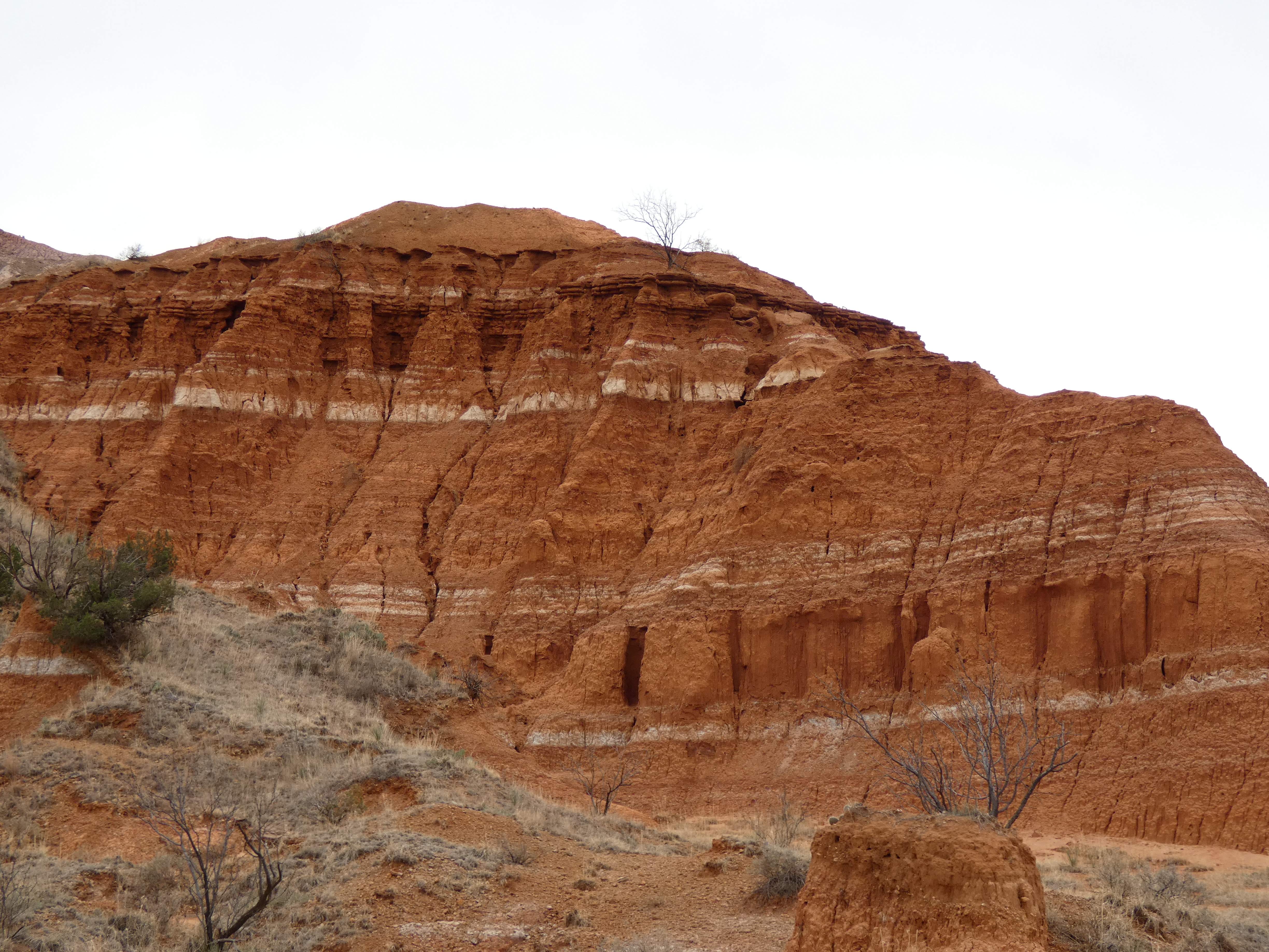
It is a cloudy and cold day, high of only 38F, winds whistling by at 20 mph, and a chance of snow. So of course we decide to hike the most popular hike in the park. Due to the cold and it being a weekday (Friday), the parking lot for the Lighthouse Trail was not full at all. We were the second car to pull in at 10:30 am. The Lighthouse is a 6 mile roundtrip hike that is mostly easy but does have some moderate rocky crossings and as you reach the end there is a steep incline to get to the symbol of the park, the hoo-doo known as the lighthouse. As we start our trek, we bundle up and tighten our hoods over our already covered heads. It sounds crazy that this is Texas, but the panhandle is known to have colder weather and it just so happened on this day, it was to be bleak and wintry. From the start the trail was impressive, we saw orange cliffs to our right with white stripes throughout. The trail was mostly soft and easy to walk on, made of orange sandy soil for most of the way. As we make our way around the canyon, we see some smaller hoo-doo formations in the distance with more orange cliffs. Along the way we have to watch where we walk due to all the spikey plants around the trail. That is definitely something to watch out for, there is a lot of cacti, thorn bushes, and thorny trees waiting to snag you in the leg, shirt, or head.
The path to the Lighthouse winds its way closer to the last climb, with the trail getting rocky in some spots. Then we can see the giant hoo-doo getting closer to us. The final ascent is made known to you by one last picnic table to stop and rest at, and a large wooden speed bump anchored to the ground to prevent bikers from going by. Once we stepped over this log, we were on a narrow dirt trail that initially took us lower into the trees along the side before turning upwards and ascending towards some large rocks. The path can be steep in some sections and covered in horse manure, watch your footing on the sandy dirt and avoid the poop. The path is not totally clear near the end, you have to scramble and climb, finding your best way up, then once past the rocks you are on a flat surface among trees and a dirt path. After that hurdle is over, you can walk easily to the Lighthouse structure and get great photos from the ground, and if you walk a little ways to the left of the base, you will see another hoo-doo behind it. We also walked up the dirt path that led directly to the Lighthouse and took turns taking pictures touching the ginormous orange rock. We were the only ones there at this time, quite a contrast to the videos we had seen of others doing this hike. We walked around a bit loving the quiet, photographing the surrounding view, and drinking water, before we made our way back to the picnic table to rest some more. By this time, the cold didn't really bother us as much, we had gotten very warm walking, and the wind would come and go depending on what part of the trail we were on. Overall, it was a great hike and based on the number of people we passed going back to the trailhead, we were glad to have done it when we did. Cold or not, this hike was getting more popular as the afternoon went on.

When we got back to the car, we were hungry and a bit worn out. We love hiking, but we don't get to do it very often, so a 6 mile hike was a lot for us to do without building up to it. We decided to check out a shorter hike further down in the park, called the Juniper Cliffside trail which leads to a cave called The Big Cave. We parked in another small parking lot near the trailhead, crossed the street to the path and began walking towards the cave with the wind blowing around us, feeling colder than it did in the morning, and little bits of ice hitting our face. Thankfully the cave wasn't too far from the trailhead, we didn't intend on completing the trail loop which was a total of 3 miles, despite it being an easy trail. The trail is pretty easy overall, not very rocky, with some steep sandy inclines at the start but the rest of the way to cave is mostly flat and you can easily spot the cave early on. The only downside to this is that we were out in the open and like I said, the wind was cold, we weren't sheltered from the elements. We tightened our hoods down and just kept trudging along. But once we saw the cave, it was worth the cold. You have to go off trail to get to the cave, there are many orange sandy paths you can take, just avoid the cactus and thorn bushes. But it makes you feel like you are an explorer on Mars, the way all the dirt is orange and you are making your own path to this mysterious cave. The cave itself is massive with a steep and rocky path leading into the opening. We did not climb all the way in, but we have seen others do it. We stopped at the bottom, and took pictures from in front. I am not sure how safe it is to climb all the way in, you would have to judge for yourself if you go there. It looked like besides climbing up the rocks in the front, you could possibly enter from the left side, if you go up a sloping path and cross over larger rocks and then climb down onto the rocks that line the cave mouth. The Big Cave was impressive, and did not disappoint. We turned and made our way back the way we came, getting pelted in the face with more bits of ice. This concluded our first day at the park and while glad it wasn't too crowded this cold day, we looked forward to sunnier weather on day two.

DAY 2
We showed up for our second day at the park earlier than day one, getting in the short line of cars at 9:30 am on a sunny Saturday. We saw many RV's arriving and were glad to have done the popular Lighthouse Trail the day before. To start this day, we pulled off the road near the visitor center to park at the Triassic Trailhead. It was a small lot that maybe fits three vehicles. We planned on making our way to Goodnight Peak and the scenic overlook which only totaled 1.2 miles round trip. The Triassic trail starts off with views of both sides of the canyon, and you are able to overlook the Park Road 5, winding below. Right when you start you can see a smaller peak just off the trail that is easy to climb and get a great panoramic view of the whole canyon. The path is mostly easy with some areas of tall rocks to climb up onto or down from. The Triassic trail meets up with the CCC trail which is considered moderate, due to some rocky narrow parts along that path. But to get to Goodnight Peak, you split from the CCC trail where there is a green metal stake in the ground. To the left is the CCC trail, and to the right is the path to Goodnight Peak. Now at first glance, it does not appear to have a trail due to the large rocks in the way, but there is a path, you just have to do some climbing initially. But once past this part, it flattens out and you are on a narrow dirt path that leads to Goodnight Peak, marked by a pile of rocks known as a cairn. From this peak you get much the same view as before on the smaller peak, you are just higher up. We continued past the peak and went to the scenic overlook at the end of this cliff, which in my opinion is better than the view from the peak. We got to see all around the canyon, and walk out to an outcropping of rock at the edge. We each got photos on this rock with the sunny canyon behind us. There is another piece of land just beyond where we stopped but it looked too dangerous to get to, it is further away than it looks in the photo. Again, we were alone at this spot and relished the peaceful solitude. After resting a bit, we went back through the very narrow dirt path to get back to where we descend to the CCC trail, avoiding more cacti and thorny trees (my husband dubbed them devil trees).


Next up we drove a few minutes further down the road to a dirt parking lot next to a bright orange Martian landscape for a 1 mile trail that isn't on the park map they give you when you enter. This trail is known as Palo Duro Caves trail, and you can find it on the All Trails app. We started off walking through some of this soft orange land, to climb up and out of a basin-like area and onto a path that leads past striped cliffs housing caves and structures that reminded me of church organ pipes. We even walk up to some of the caves to get a closer look inside. We make our way around and see some caves are way up high, but near the end there is one more cave that is low and easy enough to walk right up into. The trail gets rockier the further you go, we reach the end and turn around, getting one last look at other towering rock formations before making our way back to the parking lot.


By this time it was close getting close to lunch time and we headed over to Soapberry Day Use area, which has a decent sized parking lot, restrooms, and picnic tables. We decided to do one more short scenic overlook before eating lunch and calling it a day. Crossing the street directly across from the picnic area, there is a dirt path and a sign that says Comanche Trail, but this path is not the actual trail, but it is a spur that leads to the Comanche trail. We don't intend on doing the trail, instead we only walk the 0.3 miles to an overlook before it intersects with the trail. For this last overlook, we casually hike up an easy path and see some cool rock formations along the way. We find the overlook which is a large rock that juts out from the path, and gives you a great view of the canyon walls on the East side of the park, which we didn't get to explore on this trip. We saw some yellow and orange peaks and a large wall of white stone stretched atop the canyon wall. After snapping some photos, we head back to the picnic area for lunch. The air was still chilly, with temps only in the 40's but the sun made all the difference, keeping us warm on our treks this day. After a peaceful picnic lunch, we decided to call it and head back to our rental house.


Overall, we had a great time at Palo Duro Canyon, it is a beautiful and varied place that has hiking for all levels of difficulty. There are options for biking, horseback riding, and camping for both RV's and tents. The park is easy to get around in due to the Park Road 5 that loops around the park, and has plenty of pull off's and parking lots to stop in for the trails or for lunch. I was surprised at the many restrooms available also, I have been to National Parks with fewer amenities. Some tips I recommend are getting there early, the park opens at 7 am, the earlier you get to the popular trails, the better and less crowded it will be. Also watch out for the cacti, thorny bushes, and thorny trees, wear pants even in the summer because these plants will hurt if they scratch your skin. We went in early March and didn't see any wildlife besides birds, but I know there can be rattlesnakes, other snakes, lizards, wild turkeys, deer, coyotes, bobcats, roadrunners, and mice. So always be alert for wild animals and be aware of your surroundings. Also, wear good shoes for hiking. Even though some of the trails are rated as easy, there can still be steep, sandy spots where rocks and sand can slide right out from under you if you aren't careful. Trekking poles would be a good idea if you have balance problems, and always take extra water with electrolytes. Palo Duro Canyon is a fun and rewarding trip for any hiking enthusiast.
Happy Adventuring!